| |
Trekking along Cauvery River.
By Hemant Murthy
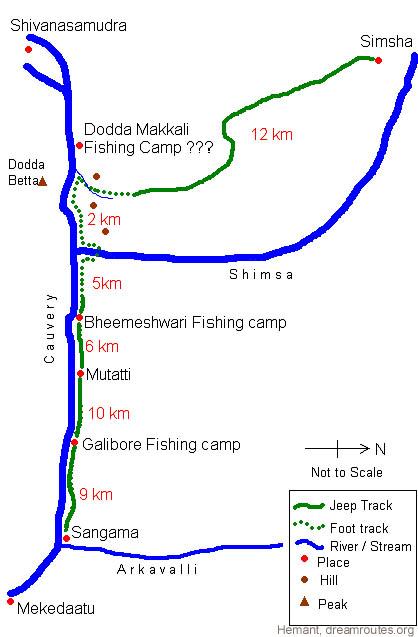
Sangama
The adventures started with
finding Gautham at the KSRTC bus stand. The Karnataka map, which
had always been a meeting place for most of our treks, had been
removed for renovation work. And Gautham was the only one who did
not know its former location. It was already 7:30 AM and we were
running behind schedule (we were supposed to leave at 6:30 AM).
Adding to this was the fact that Vinoth forgot that we even had
a trek and was conveniently asleep when Animesh called him up from
the bus stand at 6:45 AM. God know how he did it, but he somehow
managed to get to the bus stop by 7:20 AM. I had already reached
the place at 6:30 AM and in a couple of minutes was joined by Rohan
and Animesh. We decided to head to the platform for the bus to Sangama,
and on the way bumped into Gautham. He was already inside the bus
stand and was waiting for us since 6:30 AM, after giving up the
search for the elusive map.
 |
There
was no direct bus to Sangama, so we had to take the 7:45 bus
to Kanakapura (Red bus, back seat). After a smooth two hour
ride, we reached Kanakapura, and after a brief halt for breakfast
of bread, butter, jam and bananas, we were on the 10:00 AM bus
to Sangama. This was a rather bumpy ride. Initially, the bus
was rather empty but at one of the villages on the way, there
were atleast a 100 people who got on, some of them thru the
drivers door (I believe they would have gotten through the windows
too, had it not been for the grill bars). Some of them had with
them baskets of fruits, lots of chicken (some of which had a
nice time pecking away to glory at Gautham's feet), crates of
soft drink bottles, and other goods. I felt almost claustrophobic
and was thankful I had the window seat. Luckily for us, this
situation lasted only till the next village where most of the
people got off. We finally reached Sangama at 11:00 AM.
Sangama is a Sanskrit word for confluence and as
the name suggest, is the confluence of two rivers - Cauvery
and Arkavalli. Cauvery, which is the bigger of the two rivers,
has it's origin at Talcauvery in Kodagu district in Karnataka
and flows mostly south east into Tamil Nadu and empties into
the Bay of Bengal. Over its long course, this river has a number
of waterfalls and rapids and through a number of forests and
valleys, giving trekkers like us an opportunity to explore some
beautiful places along the river. And that is what we had in
mind - To walk along the river upstream from Sangama towards
Shivanasamudra, a beautiful waterfall, passing through three
fishing camps, a village named Mutatti, and another confluence.
|
Galibore
After having tea at a local tea stall, we were on our
way to the first fishing camp, Galibore, which was 9 km from Sangama.
This is owned by a tourism company called Jungle Lodges. We walked
on the jeep track from Sangama, which at times, goes along the river,
and thus gave us some good views of Cauvery. Since it is summer,
the water is a little less, and we got good views of parts of the
river bed. The rock formations looked very impressive. The weather
was on our side, since it was a little cloudy and cool. We stopped
after walking for about an hour at a spot which offered some great
scenery. Here, the water is very still and we could see the reflection
of the trees and hills on the other bank in the water. We had some
oranges and after a few pictures, we were on our way. After walking
for about an hour more, we reached Galibore. Since we had not booked
the place, we only filled up our water bottles there and were on
our way towards the next village. After about a kilometer, we found
a great spot for Lunch. It was 1:30 in the afternoon and everyone
was hungry. By this time, it was already sunny and hot. We found
a tree under which we sat and prepared lunch. Lunch comprised of
MTR heat-and-eat "Khara Bhat" and "Kesari Bhat" with pickle. Our
portable solid fuel stoves came in handy. We rested for some time
after lunch and by 3:00 PM, we started of to Mutatti, which was
10 km away.
Mutatti
After a long two and a half hour walk in the sun, we
reached Mutatti. It was sunny most of the time, but in the last
fifteen minutes, the sky was covered with dark clouds and it started
raining. We entered the forest department guest house to take shelter
from the rain. Since we hadn't booked this place either, we were
asked to leave the place after the rains subsided. Luckily we were
able to book a room in an Inspection Bunglow. This was where we
were to stay for the night. Inspite of the rains, the weather was
hot and now humid. We filled up our water bottles at a hand pump
near the bunglow (all the bottles were empty because of the long
walk in the sun).
The room was a small one with two beds. So we decided
that three of us would sleep on the floor while two would sleep
on the beds. After settling down in our room, Animesh made us some
hot tea. By 8:30 PM we cooked our dinner, which comprised of Maggi
noodles and tomato sauce. It was delicious. After that, we took
a walk in the night in the village. On returning, we made some fresh
lime juice with the lemons we purchased at a village store. At 10:00
PM we hit the sack. Or should I say, we tried to.
Why "tried to"? We were not alone in the bunglow, There
was another group of around ten people who had also come from Mysore
to Mutatti for a picnic. They had arrived there by van and they
had brought along with them enough of food and equipment to cook
for the entire village (which is what they did till 11 in the night,
much to the delight of the villagers). And after that, they all
got drunk and were dancing and singing loudly through the night
outside the bunglow till 2:00 AM (much to our agony and also the
villagers). Anyway, after their dancing and singing subsided, we
were able to get some sleep. Another exciting that did happen was
when a tiny frog got into the room from somewhere, and jumped into
my shorts. My, wasn't I jumping like a frog after that. We were
able to drive it out of the room, but not before I became an embarrassment
in front of everyone. :)
We all woke up by 6 in the morning (after sleeping for
just four hours). We all went to the river for a bath. The Mutatti
river bed looked really beautiful in the morning. After searching
for sometime, we found a good spot to bathe and were soon splashing
in the water. Gautham was a little apprehensive about the quality
of the water and hence stayed out. By 8:00 AM, we were all done
with our bath and got back to the room, where we packed all our
stuff, paid the caretaker and were soon on our way to our next destination.
Bheemeshwari
We started walking along the road to Bheemeshwari at
8:30. This place is the second Jungle Lodges fishing camp, and also
the most famous of the three in the area. It is 6 km from Mutatti
by a motorable road. We walked briskly and reached the camp by 10:00
AM. Over here, we had our breakfast of bread, butter, jam and some
tea. Some monkeys from the forest kept us company for breakfast
and we had to be extra careful with our belongings and food. Luckily,
they did not resort to much monkey business. We refilled some of
the empty bottles at the camp and then started of for the next spot.
Shimsa and Cauvery Confluence
We were supposed to walk to the third Jungle
Lodges fishing camp, Dodda Makkali. According to the caretakers
at Bheemeshwari, we were supposed to continue walking along the
road for about 2 km till we saw a jeep track turning left from the
road into the forest. The fishing camp was supposed to be around
7 km from the camp along this jeep track. There was supposed to
be a sign board indicating this turn. We started walking along the
road, which cuts throught the cauvery reserved forest area (Actually,
all the routes we walked on are inside this forest area). We say
some wild life here - Spotted deer. They ran away as soon as they
saw us, so we could not take any pictures. At one point on the road,
we got really close to the river. Over here we saw about three crocodiles.
They were hardly visible as they never left the water. Through the
binoculars, we were only able to make out their nostrils and the
path they were making in the water.
We walked on but we never found any diversion to Dodda
Makkalli. At one point, the road turned away from the river, and
it seemed like it would never turn back. So we took a left and walked
into the forest along some foot track that was barely visible. A
little ahead we reached a small settlement, where a man confirmed
that were on the right path to Dodda Makkalli. So much for looking
out for sign boards!
This walk turned out
to be the best part of the entire trek. We were walking most of
the way along the river. The forest area is rarely visited by humans
and there were signs of wild life everywhere. Along the tracks,
we could see pug marks of some big cat, along with tracks of deer
and other wild life. There were also signs of Elephants - Elephant
dung, foot prints and uprooted trees. But we never saw these animals,
other that the deer.
The river looked very spectacular. The water was much
better here. We were walking alongside it most of the way, in the
valley. There were hills on both sides, all covered with green forests.
The walk was slightly difficult and the path was barely visible
(being mostly animal tracks and not human tracks). We used the survey
map as reference, so we were confident of the way. After walking
for about two hours in the hot sun, we reached the most beautiful
spot of the trek - The confluence of the rivers Cauvery and Shimsa.
The spot looked like a beach, with white sands on the banks of Shimsa.
We had to cross Shimsa to get to the path on the other side. To
find a spot, we turned right and walked upstream along Shimsa for
about a kilometer.
Crossing the river was very tricky. Since the bed was
rocky and all the rocks were covered with moss, it was very slippery.
So we had to cross the river barefoot. And because of the heat,
all the rocks outside the water were hot enough to fry eggs. So
we could not stand outside the river for longer than a few seconds.
Adding to this was the load of our bags. Most of crossed without
much problem. Animesh and I had minor falls, because of which his
bag and my shoes were soaked in water. Other than that we had no
other problems.
We rested on the other side of the river and Rohan and
I prepared lunch while the remaining three bathed in the river.
The spot was very beautiful. It looks like a white beach on the
bank of the river, which was shaded by trees on the edge of the
forest. The confluence is surrounded on all sides by hills, all
of which were covered with green forests. This spot is atleast 5
km from anything that you can call human contact and 10 km from
the nearest village, and hence a very secluded place. The only way
to get here is on foot, the way we did.
Lunch was again, MTR heat-and-eat Khara Bhat and Kesari Bhat. By
3:00 PM we were done with Lunch and were ready for the next leg
of our trek.
Shimsapura
The next leg proved to be very exciting. It was already
3:30 PM and we were yet to reach Dodda Makkali. Shivanasamudra,
our intended destination, was atleast 15 km away. To reach the fishing
camp, we were supposed to walk along Shimsa and then along the Cauvery
we reached the camp. We had no idea of how far we were supposed
to go to reach the camp itself, since the map did not show this
place. However the map did show a jeep track somewhere above on
the hills near the confluence, which would take us to the village
of Shimsapura, from where we could take a bus. Shimsapura was about
14 km from where we were. So we decided to take that instead of
trying to find the way to Shivanasamudra and getting lost in that
forest.
Finding the jeep track was easier said than done. At
one point, we were at a spot directly opposite a mountain named
Dodda Betta on the opposite bank. This mountain has a characteristic
double hump, which made it very easy to identify. The foot track
to reach the jeep track was supposed to start much before this spot,
but for some unknown reason we never found it. So we climbed the
hill along the nearest stream, the top of which according the map,
reaches the start of the jeep track. And to our good fortune, we
found the track. But it was no longer a jeep track anymore and was
merely a foot track (or animal track). By the looks of it, it seemed
like it had not been used for years.
We walked along this track, which crossed through the
cauvery forest. The forest was not very thick but it was impressive.
Elephants could easily hide in the foliage, and we were being cautious,
listing to everything as we walked through the forest. The foot
track eventually got wider and started looking like a jeep track.
After about 8 km it joined a more prominent track, which we speculated
lead to the fishing camp. Anyway, we walked along towards Shimsapura
and by about 7:00 PM, we reached the village, thus ending our adventurous
trek.
Shimsapura is a small village, and also has Asia's
first Hydro-electric power plant, which generates power not from
a dam, but from a waterfall (98 m high). We got water from the police
station and some bananas from a shop. There was no direct bus to
Bangalore, so we took the 7:45 bus to the town of Malavalli, and
after having our dinner there in a hotel, we took the 8:30 bus to
Bangalore. We reached Bangalore after a very bumpy two and a half
hour ride. The only thing I could think of after getting home was
sleep, which I did in no time, dreaming about our adventures and
the fun we had.
Hemant
9 April, 2003
Trek ratings:
Difficulty: Easy-Moderate (depends a lot on the weather)
Distance: Between 44 and 47 km from Sangama to Shimshapura or Shivanasamudra
Terrain: Mostly along the river. Jeep tracks or foot tracks most
of the time. Not much of ascent anywhere. Mostly flat.
Number of days: Two days
Expense: Rs. 300-400 per head, inclusive of transport, food and
equipment
Afterthoughts
You need to start very early on day 1 if you want to
make it to Bheemeshwari on day 1 itself. This could be a problem
when it comes to staying, as Bheesmeshwari is a Jungle Lodges camp
and is very expensive (Rs. 1250 per night!!). Private camping is
not allowed, so you may have to camp a little before or after the
fishing camp, and this means staying in a forest known for Elephants
and other wild life. So it would be better to make a halt as we
did, in Mutatti. In that case you need to leave Mutatti much earlier
than what we did, in order to reach Shivanasamudra on time for a
bus back to Bangalore (I believe the last bus leaves at 6 from Shivanasamudra).
This trek route can be extended starting from Hogenekal
falls right upto Shivanasamudra, and even beyond, making it a 80-85
km venture. This can be done over 3-4 days.
|
|