| |
MuLainagiri
– Right on the Top !

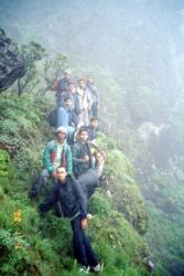
This august 15th was extra special for 10 of us. Not just
because it was a day of patriotic fervor, also because we were all
set to celebrate it on Top of Karnataka at a height of over 6,000
feet !
MuLainagiri is the highest peak in Karnataka and happens to be one
of the topmost heights between Himalayas and the Nilgiris. Phew, quite
a big reputation !
We
guys were excited with this trip. It had been quite some time
since a we had a 3 day vacation and more people had come on
this trip. Last time we went as a group was to HonnemarDu, which
was a super success. We guys boarded a Chikmagalur bus on Thursday
night and landed at around half past four. Our plan was to trek
our way to the summit from a spot called 'Sarpandari' (Snake
path in Kannada) on the road to Kemmangundi This place is on
the road side and has an arch as its entrance and a path that
goes uphill and nothing else. On knowing that the first bus
during this time of the year started only at 8, we decided to
take an auto (true bangaloreans :)) to Sarpandari. This auto
journey was some 20 km long, and as we moved out of the town
limits, the mist and the chill caught our imagination.
The entrance to Sarpandari has an arch which tells
you when it was erected etc., MuLainagiri (AKA mullainagiri,
mullenagiri) is also called MuLLaina maTa. Sarpandari true to
its name has swirling pathtrails. The excitement begins at the
onset itself. I found it slippery. We found it slippery. Added
to this was the dew in the grass. There are many deviations
all along the way. Make sure you take the one which goes up
and most of the times it’s the left one. This is not very tough
to find out though. There are pockets where the slope is close
to 40-50 degrees and can really freak you out. The small guy
in our group needed lots of moral & physical support to get
through this stretch. Once, this is over, its cake walk. There
are places where you can rest, be amazed at the path you have
taken and look beyond that to appreciate the heights ! Even
perhaps, leeches cannot climb these heights :) But, we guys
were unlucky, blinded by the cloud and mist. Sometimes, reducing
visibility to not more than 10 feet.
|
 |
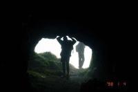
There are a couple of small caves just below the peak,
you can go exploring into them for some 100-200 ft. There are a couple
of statues of nandi (bull) along the way. One of them was below a
tree, and there were beautiful pink flowers which simply magnificent.
Instantly cameras clicked here.
 |
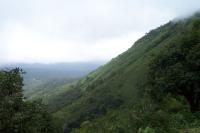
After some 2-3 hrs of trekking, we reached the top
of Karnataka ! Its an awesome experience, which is tough to
describe, easy to feel. You see the clouds coming into you,
accompanied by some rain. You feel like shouting – shouting
that you are over 6000 ft. You feel like running around the
place have a glimpse of the cliffs, look for any remote villages
which look like miniature pictures, search for any rivers flowing
nearby. But, most of the excitement was dampened by the poor
visibility and the chill. So, summer seems to be the best time
to come here but it’s a tradeoff, like lotsa things in life.
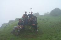
True enough to the spirit of the day, we guys held the flag
we had taken high in the air.
|
There is a temple out there, dedicated to God Shiva. The priest's
home is also there on the top of the mountain. We went around the
place. Anyways, were were happy with the place and after some breakfast,
decided to head towards Bababudangiri.
| But, don’t know
what happened after we got off from the summit, we lost the
way. We were told by the priest that Bababudangiri was close
by and trekking was possible. But, just after 10 mins from the
summit, we were truly lost in the mountains and clouds. In spite
of following the specified path, we had in fact headed back
to Kemmangundi rd and were intercepting the road before Sarpandari.
There was no use heading back, since we did not find any other
probable path. The path that we followed (inevitably) got us
back to Kemmangundi rd, along some jeep track. This route passed
through some place called 'Seethayyana maTa'. Some informed
souls may laugh at us for taking this route. But, we were truly
lost. To top it all, it was raining quite heavily, but we kept
going because there was no place for shelter.Along the way,
as we |
 |
descended from the heights, we were moving away from the thick clouds,
visibility was getting better but, we did not have the heights to
have a great view. This walk was some 10-12 km and it was about 3
when we landed on the road.
 |
After some quick
chapathis and jam, we waited for the Kemmangundi bus to come.
This blessed bus (with a blessed driver) came at 5 and carried
us to Bababudangiri. It was around half past 6 when we came
to Bababudangiri, and we're greeted with heavy mist and rain.
We tried to seek some decent accommodation, but all we got was
some petty room, which was intended to be a shop during the
Urs season. We decided to head back to Chikmagalur. Before that
we made a brisk visit to the Shrine. This particular shrine
is housed in a beautiful cave, and legend has it that Baba Budan
(known to be a great healer, who is also credited with bringing
coffee to this part of the world) meditated here and disappeared
through a path inside the cave. |
Samadhis of 4 of his followers and his mother are also here. This
place is worshipped by Hindus and Muslims alike. One peculiar practice
for offering prayers here is to tie a lock to a window pane inside
the shrine.
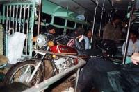
| I must mention about
the bus ride back to Chikmagalur. This blessed bus passed thro'
some of the narrowest roads and carried anything from people
to bikes, yes motor bikes ! We only hoped that the prayers offered
at Bababudangiri will carry us through till Chikmagalur. Chikmagalur
was a haven for us. We got into some good accommodation and
were fast asleep without a sound. We could have boarded a bus
to Bangalore but decided to go to Kemmangundi the next day and
thus stayed on. |
 |
Facts :
Height : 6317 ft, heighest in Karnataka, heighest peak between Himalayas
and Nilgiris
Distance : about 20 km from ChikmagaLur which is 4 hrs journey from
Bangalore
Nearby places : Bababudangiri, Kemmangundi
- Compiled by Nithin on 4/9/2003
|
|