| |
Around CharmaDi
Deepawali
was on 24th (Friday) and everyone had the same thought, runaway from
Bangalore... so it was nothing different for us as we started planning
for some new routes that we could trek. We first had the idea to do
some route near Madanapalli to Tirupathi but the person who gave the
idea got injured a week before.. hmmm.. Planned to trek around Agumbe
and contacted Mr.Pai in Agumbe but got a reply that it is not the
ideal time to trek as it was still raining.. So deepawali is just
another week and we were still deciding.. Thanks to Lacchi and Ravee..
they contacted Mr. Dinesh holla of Mangalore and got some info on
trekking some places around Charmadi. Charmadi is one of the beautiful
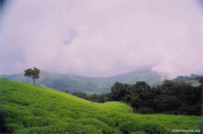
ghat sections in Western ghats (Sahyadri). So we (five, Lacchi, Ravee,
Kiran, Ganesh and me) were geared up to visit some five waterfalls
around Charmadi ghats.
| The
D-day arrived and we were set to meet at Bangalore Bus station
at 9:30. The rain god had shown mercy on Bangalore after a serious
of drought ridden seasons, he was in full swing, intermittently
resting for few minutes and roaring for another few minutes.
So it was difficult to distinguish between the pot holes, drainage
and roads at some places. Added to this there were vehicles
at every where. I started at 8:30 and was not able to find a
bus nor an auto till 9:00. I had to run back home, take my vehicle
and reach the bus stand. I reached by around 10, thanks to the
traffic jam. I knew how the Bangalore bus stand would be, since
I've been traveling during these clubbed holidays and if anybody
needs to know, better try out some time, coz all I can say is
Chaos, Chaos and only Chaos. |
 |
So finally we left to Dharmastala and reached
there by around 6 in the morning. Early in the morning took another
bus reached Ujire, took another bus and finally reached Charmadi.
Charmadi is a small
village at the foothill of the Ghats which is named after. We went
to this hotel (Hotel charmadi) and had our morning breakfast and was
eagerly waiting for our guide (suggested by Mr. Dinesh holla) Esubu
(this was what we were informed) and after talking to the guide came
to know that his name was Yousuf. He finally arrived at around 8:00
a.m had breakfast and some small introduction and the plan for the
day was to go to Alekan waterfalls and then climb Jenukallu gudda,
Kodekallu gudda etc. We then set off in a Mini lorry, and mind you,
it is one of the best experiences and views you can get when you travel
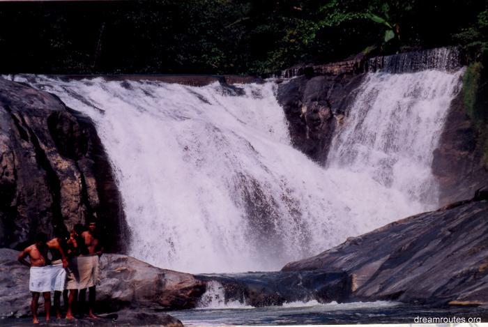
in a open top vehicle. We finally got down at Alekhan falls, which
is adjacent to the Road. This is around 15-20 kms from Charmadi towards
Moodigere.
 |
The waterfall was exquisite, what made it more interesting was
the pink flowers in between the water falling. I missed my camera,
but ravee should have captured it good. We spent some time out
there and then started to walk. The first adventure began at
the start itself. The place where we got down was Alekan watefalls
and there was a bus stop named Alekan bus stop. There was a
road going uphill to a peak via some estate. The guide was taking
us on the road and through another path. Lacchi, Ravee and myself
followed the guide expecting Kiran and Ganesh to follow us but
they had other ideas. The asked some of the local who misguided
and took the uphill route. |
We walked for about half a kilometer and waited
there and then thought they could have taken the other road and
I went looking for them and in the mean time they fortunately asked
another person who informed he saw none of us on the road and they
were heading down. Finally we were regrouped and started walking
on the road.
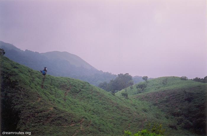
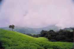
| Walking
on the road we were have some superb views of the peaks and
valleys and almost every peak had a name. We were walking on
the road for quite some distance and it was an irritating experience.
We finally reached signboard pointing to Bidiruthala village
where we took a deviation and started climbing the peak. So
the plan was to go up the Jenukallugudda(jenu - honey, is named
after coz there are a lot of bee hives on the rock). The climb
was a bit hard, adding to the humidity. We walked for about
30 minutes and we reached the uphill from where we could see
the small village. We headed towards Jenukallugudda. Up there
there were a lot of peaks (gudda's) and we were asking the guide
can we go there, can we go here etc. He had answer for everything.
|
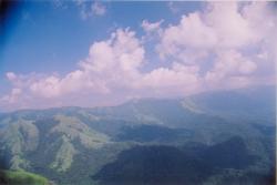 |
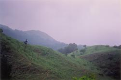
We bypassed jenukallugudda (since it was
a bit lower to the place where we already where) and then carried
on towards Kodekallu gudda (Kode - umbrella, kallu - stone, gudda
peak)named because it has a Stone which has an overhang and umbrella
kind of shape, but before reaching that we started towards Balekallu
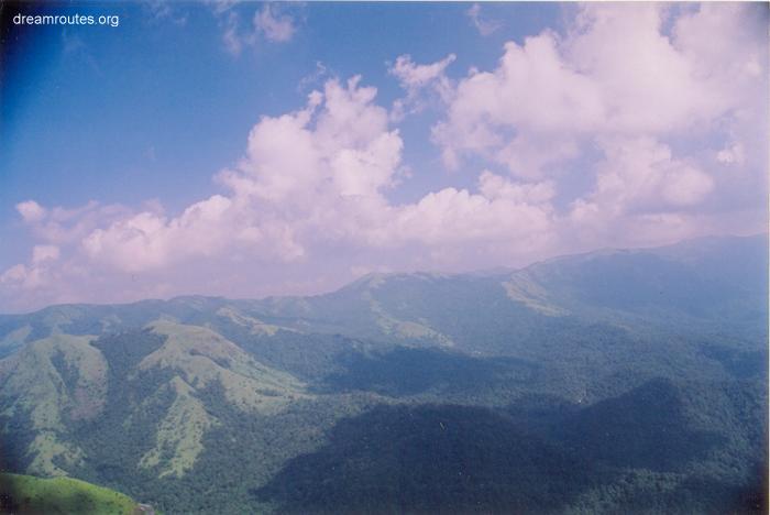
gudda. For the surrounding peaks, it seemed balekallu gudda was the
top most and we started climbing. The views of other peaks and the
sholas was breathtaking, shot the views where ever possible.
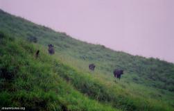 |
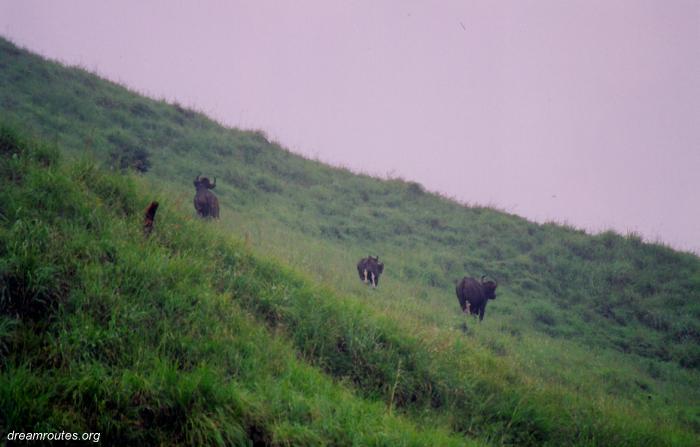
There was some
surprise ahead of us, as we were climbing bale kallu gudda the
guide whispered Bison.. Bison, get down. He was in the front,
followed by me, ravee, kiran, ganesh and lacchi. We hid ourselves
behind grasses and ravee came with his camera and when we had
a view it was two bisons with its younger ones. What an amazing
sight.. thought we were blessed.. Ravee had some shots and then
they sensed us and ran away from us. We climbed the peak and
we found another massive bison resting. We took some shots of
it and after a while it moved into the forest but limping (not
sure how it had happened). We stayed around few minutes at the
peak and got down to Kode kallu. |
The rock here is very big and as mentioned
has a overhang. If there is a nearby waterspot, it's a very nice place
to tent. We further carried on and got onto the road, took a lorry
and got down to this small hut kind of stuff, just around 4 kms from
Charmadi.
Jenukallu gudda ,and
kodekallu gudda are high points on the same hill,the highest point
being called Balekallu gudda. One can spot kodekallu quite easily
which driving on the ghat road.
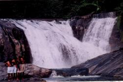
| We
had a nice dinner, quite spicy ones, credit to lacchi. The guide
left us to join us again in the morning. The plan of the day
was to go to Dhondole waterfall (this river is on one of the
tributaries which joins into Nethravathi), which is around 12-14
kms from charmadi. We had our spicy breakfast in the morning
again.. huh.. We then walked till charmadi and then took an
auto till kakkinje, took a jeep for another 8-10kms (don't know
the place though) and then started walking after crossing the
stream. It was a one hour walk, the path was not very clear
as there were lot of plants and shrubs grown on the path. On
the way we saw some good boulders too. We finally reached the
waterfall at around 2 p.m. Yousuf advised us not to go under
the waterfall (because of deep water and the fast flow ) and
no one ventured into that adventure either. |
 |
Had a nice time till 4:30, had our lunch,
no need to mention the creditor again!!! Yes, you guessed it right,
it was lacchi again, and the spice was so much that ravee ditched
the lunch. We got back to the place where the jeep was waiting for
us, dropped the guide at kakkinje and further traveled to dharmastala
to take a night bus to Bangalore.
So all in all, it
is a nice place to trek, except that there are a lot of routes which
goes here and there. Yousuf also mentioned you could do something
like 4-5 day treks in the forest. I think he knows the forest quite
well and can guide a group very well. I got an idea of doing cycling
from dharmastala to chickamagalur (100kms), but yet to see if I
can do it, if so when!!!!
Pursuits:
Ballalrayandurga to
bale kallu gudda would be interesting. This route will take 5-7 days,and
involved getting down one massif into the shoal and then up onto the
other. The route from dharmasthala till mudigere/chikmagalur is eminently
cyclable. The road does not see much traffic in daytime,and the road
surface is very good . However,gradients are pretty steep,so more
the gears the merrier.
~~ S Laxminarayan.
|
|